
Historic


MepBay (or MEPPE in the Portuguese version) is a computational tool that assists in the analysis of planform equilibrium in bay beaches (Figure 1). Using satellite images, aerial photographs, or maps of the beach under study, the application incorporates the location of the promontory, the location of the end of the beach, and the predominant wave direction (data for the calculation of the empirical models by Hsu & Evans, 1989). With this information, the application can calculate the theoretical shoreline and draw it on the screen. By comparing the coastline drawn through the application with the observed coastline in images or maps, the user can determine the type of equilibrium the beach is in (Hsu et al., 2008).
The development of the MepBay application began in 1999, and its objectives and improvements have been disseminated in conferences and journals (more information can be found in the publications menu). Over the years, the project has aimed to build new versions of this application, overcoming limitations identified through continuous tool usage, as well as addressing restrictions pointed out by Lausman (2006). Given the identified requirements for improving the application, the development platform was changed to adopt the Java language instead of Object-Pascal. This decision was also supported by the existence of suitable libraries and documentation to assist in the development of the latest offline version from 2010, which is partially updated in 2022.
In a new phase, MEPBAY will be implemented in CASSIE – Core®, an online version.
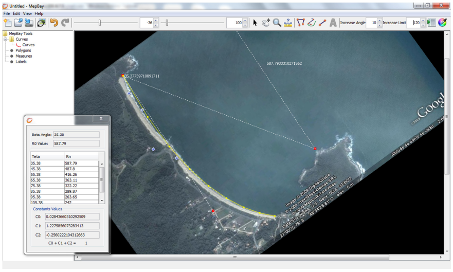 Figure 1: Demonstrative image of a project being carried out in the MepBay application. Source: MepBay application.
REFERENCES:
- Hsu, J. R-C., Evans, C. Parabolic Bay Shapes and Applications. In: Institution of Civil Engineers – Part 2, 1989, Londres. Proceedings… Londres: Thomas Telford, p.557-570, 1989.
- Hsu, J. R. C.; Benedet, L.; Klein, A. H. F. ; Raabe, A. L. A. ; Tsai, C. ; Hsu, T.; Appreciation of Static Bay Beach Concept for Coastal Management and Protection. Journal of Coastal Research, v. 24, p. 198-215, 2008.
- Lausman, R. F. Uncertainty in the application of Bay Shape Equations. A study on the quantification of the uncertainty in the application of the Parabolic Bay Shape Equation using existing bays. Diss. Master thesis, Delft University of Technology, Faculty of Civil Engineering and Geosciences, Section of Hydraulic Engineering. 100p (www. library. tudelft. nl), 2006.

